


Borehole imaging plays a crucial role in sedimentology, providing detailed visual and structural data from boreholes that help in understanding sedimentary processes, depositional environments, and the characteristics of subsurface formations. This technique is particularly valuable in the oil and gas industry, groundwater studies, and environmental geology, where accurate sedimentological analysis is necessary for resource evaluation, reservoir characterization, and environmental assessments.
Key Applications of Borehole Imaging in Sedimentology:
- Identification of Sedimentary Structures:
- Primary Sedimentary Structures: Borehole imaging allows for the identification of primary sedimentary structures such as bedding planes, cross-bedding, ripple marks, and graded bedding. These structures provide insights into the depositional environment, sediment transport mechanisms, and energy conditions at the time of deposition.
- Bioturbation and Ichnofossils: Bioturbation, or the disturbance of sediment by living organisms, and the presence of ichnofossils (trace fossils) can be identified through borehole imaging. These features are important for interpreting past environmental conditions and the presence of life in ancient sediments.
- Facies Analysis:
- Lithofacies Identification: Borehole imaging helps in identifying different lithofacies, or rock types, based on visual characteristics such as grain size, texture, color, and sedimentary structures. This information is crucial for reconstructing depositional environments and understanding the spatial distribution of sediments.
- Facies Mapping: By analyzing multiple borehole images, geologists can create facies maps that depict the lateral and vertical variations in sedimentary environments. These maps are essential for predicting reservoir quality and understanding sedimentary basin evolution.
- Grain Size and Texture Analysis:
- Grain Size Distribution: Borehole imaging tools can provide qualitative assessments of grain size distribution within the sedimentary sequence. Understanding grain size variations helps in interpreting energy levels during deposition and the sorting mechanisms at play.
- Sediment Texture: Textural features, including sorting, roundness, and grain packing, can be observed in borehole images. These characteristics are important for determining reservoir quality, as well as porosity and permeability.
- Depositional Environment Interpretation:
- Fluvial, Deltaic, and Marine Environments: Borehole imaging provides critical data for interpreting depositional environments, such as fluvial channels, deltaic deposits, and marine settings. Each environment is characterized by distinct sedimentary structures and facies that can be identified in borehole images.
- Transgressive and Regressive Sequences: The identification of transgressive (sea-level rise) and regressive (sea-level fall) sequences is possible through borehole imaging, which helps in understanding the history of sedimentary basins and their stratigraphic architecture.
- Sequence Stratigraphy:
- Identification of Stratigraphic Boundaries: Borehole imaging can help identify key stratigraphic boundaries, such as unconformities, flooding surfaces, and sequence boundaries. These boundaries are critical for sequence stratigraphic analysis and understanding the timing and nature of sedimentary cycles.
- Parasequences and Systems Tracts: Detailed borehole imaging allows geologists to identify and correlate parasequences (small-scale depositional units) and systems tracts (packages of sediments deposited during specific phases of sea-level change). This is essential for reconstructing the sequence stratigraphic framework of a basin.
- Diagenetic Features:
- Cementation and Compaction: Borehole imaging reveals diagenetic features such as cementation (the precipitation of minerals within the pores of sediment) and compaction (the reduction of pore space due to overburden pressure). These features influence the porosity and permeability of the sediment and are important for reservoir quality assessment.
- Dissolution and Replacement: Diagenetic processes such as dissolution (the removal of minerals) and replacement (the substitution of one mineral by another) can be detected through borehole imaging. These processes impact the rock’s mechanical properties and its behavior during production.
- Core-to-Log Correlation:
- Visual Correlation with Core Data: Borehole imaging data is often correlated with core samples to validate interpretations and enhance the understanding of sedimentological features. This correlation helps in bridging the gap between direct observations from cores and continuous data from well logs.
- Integration with Petrophysical Logs: Borehole imaging data is integrated with other well logs (e.g., gamma-ray, resistivity) to refine sedimentological interpretations and improve the accuracy of reservoir models.
- Reservoir Characterization:
- Porosity and Permeability Estimation: Sedimentological features identified through borehole imaging, such as grain size, sorting, and diagenetic alterations, directly influence porosity and permeability. Understanding these features helps in predicting the quality of reservoirs and their potential productivity.
- Heterogeneity and Continuity: Borehole imaging provides insights into the lateral and vertical heterogeneity of sedimentary units, which is critical for understanding reservoir continuity and connectivity. This information is vital for optimizing well placement and recovery strategies.
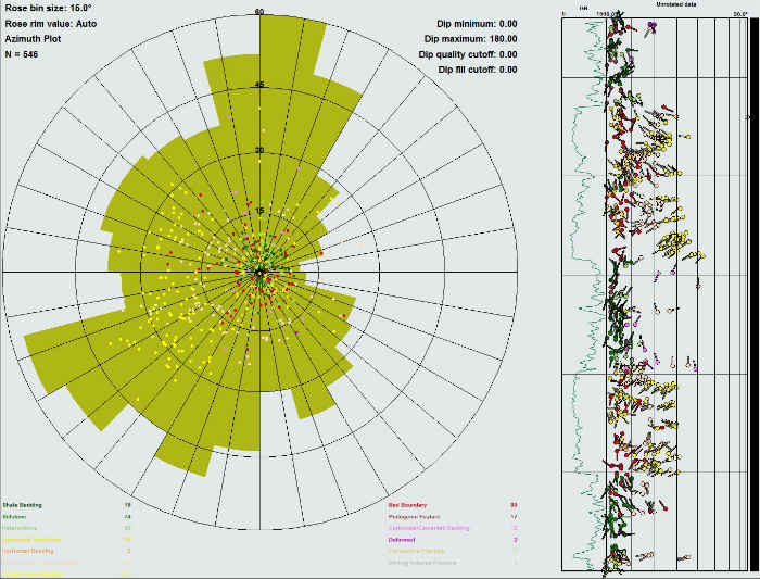
- Paleocurrent Analysis:
- Cross-Bedding and Ripple Marks: Borehole imaging can reveal cross-bedding and ripple marks, which are indicators of paleocurrents (the direction of water flow at the time of deposition). Paleocurrent analysis helps in reconstructing the sediment transport pathways and the paleogeography of the depositional environment.
Tools Used in Borehole Imaging for Sedimentology:
- Optical Televiewer (OTV): Provides high-resolution optical images of the borehole wall, allowing for detailed analysis of sedimentary structures and lithology in clear fluid environments.
- Acoustic Televiewer (ATV): Uses ultrasonic pulses to generate acoustic images, suitable for environments where borehole fluids are opaque or where optical tools are less effective.
- Formation MicroImager (FMI): Produces high-resolution resistivity images that are particularly useful in identifying fine-scale sedimentary features, especially in electrically resistive formations.
Conclusion:
Borehole imaging is an essential tool in sedimentology, providing detailed visual data that enhances the understanding of sedimentary processes and depositional environments. Through the identification and characterization of sedimentary structures, facies, and diagenetic features, borehole imaging supports more accurate reservoir characterization, improves sequence stratigraphic analysis, and aids in the interpretation of depositional history. The integration of borehole imaging data with core samples and petrophysical logs allows for a comprehensive understanding of subsurface geology, leading to more informed decision-making in resource exploration and development.