


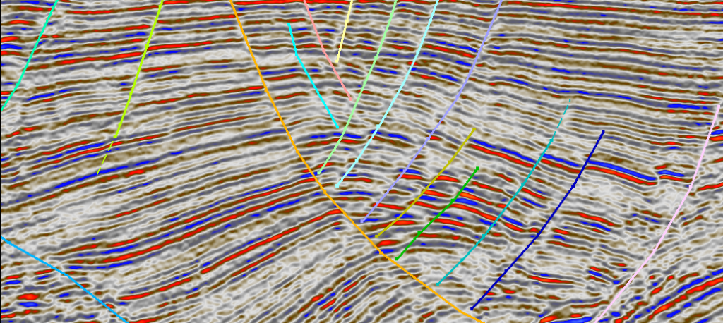
Syntillica has the expertise to offer end-to-end consulting support in the areas of seismic survey tendering, design, acquisition and processing services. Seismic acquisition has been the mainstay of exploration and field development for decades.
In that time the technology underlying both acquisition and processing has increased enormously in a highly competitive market. To make the most suitable choices for seismic from a cost benefit viewpoint is no easy matter.
We take an independent and rigorous view of contractor performance to provide assessment and advice on tendering and selection. We also have the technical expertise to offer survey design, acquisition and processing QC services to guide you on the path from concept to geophysical interpretation, quantitative analysis and more.
Syntillica also offers Site Investigation services: Geo-Hazard or Shallow Hazard Assessment. Integration of specialist geophysical interpretation, geotechnical, geological and environmental information to identify near surface risks to drilling, pipelines and rig infrastructure.
Seismic processing quality control (QC) is a critical step in ensuring that seismic data is accurately processed and reliable for interpretation. Seismic data processing involves a series of complex steps, including data acquisition, noise attenuation, velocity analysis, migration, and more. QC is performed at each of these steps to ensure the data quality is maintained and that any errors, artifacts, or inaccuracies are identified and corrected.
Objectives of Seismic Processing QC
1. Ensure Data Integrity:
– Verify that the seismic data maintains its fidelity throughout the processing steps and that no significant information is lost or distorted.
2. Identify and Correct Errors:
– Detect any processing errors, artifacts, or inconsistencies that could compromise the final seismic image and correct them.
3. Optimize Processing Parameters:
– Ensure that the processing parameters are optimally chosen for the specific characteristics of the data, leading to the best possible seismic image.
4. Maintain Consistency:
– Ensure that the processed data is consistent across different areas of the survey and over time if multiple datasets are involved.
5. Document the Processing Workflow:
– Maintain a detailed record of all processing steps and parameters for future reference and to ensure reproducibility.
Key Steps in Seismic Processing QC
1. Data Input QC:
– Objective: Check the integrity of raw seismic data as it is imported into the processing system.
– Tasks: Verify the completeness of data, check for missing traces, assess the signal-to-noise ratio, and ensure that the recording parameters match the expected survey design.
2. Geometry and Navigation QC:
– Objective: Ensure that the spatial positioning of seismic traces is accurate.
– Tasks: Check the shot and receiver locations, verify the correct application of navigation data, and ensure that the geometry is correctly implemented in the processing system.
3. Noise Attenuation QC:
– Objective: Verify that noise removal techniques (e.g., de-bubbling, ground roll removal, and multiple suppression) are effective without harming the true seismic signal.
– Tasks: Evaluate the effectiveness of noise attenuation processes by comparing pre- and post-processed data and checking for any residual noise or signal degradation.
4. Amplitude and Phase Consistency QC:
– Objective: Ensure that amplitude and phase relationships are preserved or corrected throughout processing.
– Tasks: Monitor amplitude variations across traces, check phase alignment, and ensure that amplitude-preserving processes (e.g., deconvolution, gain recovery) are properly applied.
5. Velocity Analysis QC:
– Objective: Validate the accuracy of velocity models used for processing steps such as normal moveout (NMO) correction, stacking, and migration.
– Tasks: Cross-check velocity picks with well data, horizon picks, or other geophysical data to ensure accuracy and consistency. Ensure velocity models are updated iteratively based on feedback from imaging results.
6. Static Correction QC:
– Objective: Ensure that static corrections (to account for near-surface velocity variations) are correctly applied.
– Tasks: Verify the accuracy of static corrections by checking consistency across the survey area and ensuring that they improve data coherence.
7. Migration QC:
– Objective: Validate the accuracy of the migration process, which positions seismic events at their true subsurface locations.
– Tasks: Check for correct imaging of subsurface structures, monitor for migration artifacts (e.g., noise, multiples), and confirm that the chosen migration algorithm is suitable for the data type (e.g., time migration vs. depth migration).
8. Multiple Attenuation QC:
– Objective: Ensure that multiples (reflected energy that bounces more than once before being recorded) are effectively suppressed without harming primary reflections.
– Tasks: Evaluate the effectiveness of multiple removal techniques, such as predictive deconvolution or surface-related multiple elimination (SRME), by comparing data before and after processing.
9. Final Stack QC:
– Objective: Review the final stacked seismic sections for overall data quality before migrating.
– Tasks: Assess data continuity, amplitude balance, and any remaining noise or artifacts. Ensure the stack represents the best possible combination of traces.
10. Final Migration QC:
– Objective: Validate the final migrated seismic image for accuracy in depicting subsurface structures.
– Tasks: Check for proper imaging of key horizons and faults, verify depth conversion accuracy, and ensure that migration artifacts are minimized.
11. Attribute Analysis QC:
– Objective: Ensure that seismic attributes (e.g., coherence, amplitude variations, etc.) are accurately derived and represent true subsurface features.
– Tasks: Compare attributes against known geological features, check consistency across the dataset, and validate the processing steps used to generate attributes.
12. Time-Lapse (4D) Seismic QC:
– Objective: Ensure consistency and accuracy in time-lapse seismic data, used to monitor changes in a reservoir over time.
– Tasks: Compare seismic data from different time periods, ensure that processing is consistent across datasets, and accurately detect changes in the subsurface.
Tools and Techniques for Seismic Processing QC
1. Visual Inspection:
– Purpose: Manually inspect seismic sections and gather visual feedback on data quality.
– Application: Identify obvious issues such as noise, amplitude inconsistencies, and structural anomalies.
2. QC Plots:
– Purpose: Use various plots (e.g., RMS amplitude, frequency spectra, gather consistency) to evaluate data quality quantitatively.
– Application: Detect trends, anomalies, or processing issues that may not be apparent in visual inspection alone.
3. Interactive Software Tools:
– Purpose: Utilize software tools for interactive QC, allowing real-time adjustments and feedback.
– Application: Tools like seismic processing software suites (e.g., ProMAX, Petrel, or Omega) provide built-in QC functionalities.
4. Cross-Checks with Other Data:
– Purpose: Validate seismic data against well logs, VSP (Vertical Seismic Profile), or other geophysical data.
– Application: Ensure consistency between seismic and other subsurface data types, reducing the risk of misinterpretation.
5. Attribute Analysis:
– Purpose: Derive and inspect seismic attributes to identify potential issues.
– Application: Analyze attributes such as coherence, amplitude variations, and AVO (Amplitude Versus Offset) to check for data quality.
6. Time-Lapse Comparison:
– Purpose: In 4D seismic, compare datasets from different time periods to ensure consistency.
– Application: Detect real changes in the reservoir as opposed to artifacts introduced by inconsistent processing.
Conclusion
Seismic processing QC is an essential process in ensuring that the final seismic data is accurate, reliable, and ready for interpretation. By performing rigorous quality checks at each step of the processing workflow, geophysicists can identify and correct issues early, maintain data integrity, and produce high-quality seismic images. This process ultimately leads to better decision-making in exploration, development, and production, reducing risks and enhancing the understanding of subsurface geology.
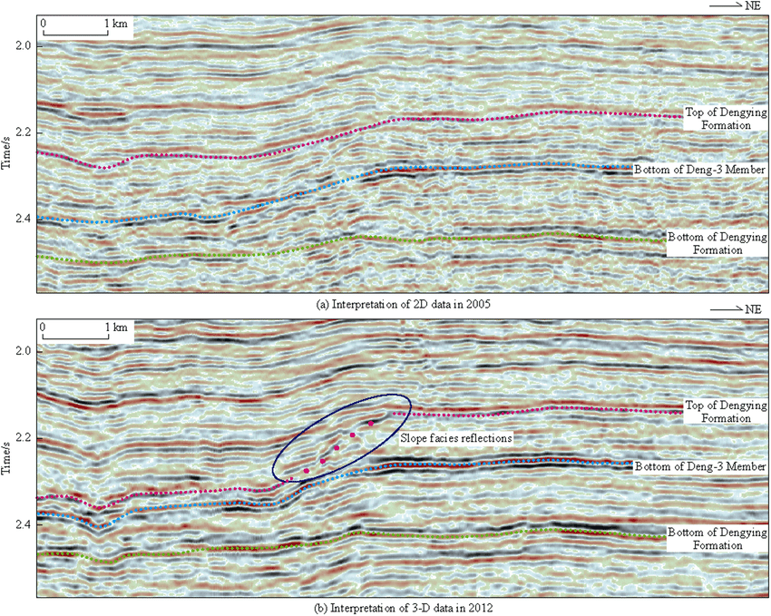
Seismic data review and recommendations involve a thorough evaluation of seismic datasets to assess their quality, accuracy, and usefulness for subsurface interpretation. The review process identifies potential issues in the data, assesses the effectiveness of processing steps, and provides recommendations for improvements or further analysis. The ultimate goal is to ensure that the seismic data is optimized for accurate geological and geophysical interpretation, supporting exploration and development decisions.
Objectives of Seismic Data Review
1. Assess Data Quality:
– Determine the overall quality of the seismic data, including signal-to-noise ratio, resolution, and continuity of seismic events.
2. Evaluate Processing Effectiveness:
– Review the processing workflow and assess the effectiveness of each step, such as noise attenuation, deconvolution, migration, and multiple suppression.
3. Identify Data Issues:
– Detect and document any problems in the seismic data, such as artifacts, amplitude inconsistencies, or velocity errors, that could affect interpretation.
4. Provide Recommendations:
– Offer specific suggestions for reprocessing, additional processing steps, or alternative methodologies to improve the seismic data quality.
5. Support Interpretation:
– Ensure that the seismic data is in a state that supports accurate subsurface interpretation, leading to better decision-making in exploration, development, and reservoir management.
Key Components of Seismic Data Review
1. Initial Data Assessment:
– Objective: Conduct a preliminary review of the raw and early-stage processed seismic data.
– Tasks: Assess data completeness, quality of the input data, and initial noise levels. Check for missing traces, bad shots, or poor quality data sections that might need re-acquisition or special processing attention.
2. Processing Workflow Review:
– Objective: Evaluate the seismic processing sequence to ensure it is appropriate for the data and the geological objectives.
– Tasks: Review the processing steps applied (e.g., deconvolution, static corrections, velocity analysis) and assess their impact on data quality. Ensure that the processing parameters are optimized and appropriate for the specific dataset.
3. Noise and Artifact Identification:
– Objective: Identify and analyze noise and artifacts in the seismic data.
– Tasks: Examine the data for coherent and random noise, multiple reflections, side-lobes, and migration artifacts. Determine the sources of these issues and their potential impact on the seismic interpretation.
4. Amplitude and Phase Consistency Check:
– Objective: Ensure that the amplitude and phase of seismic events are consistent across the dataset.
– Tasks: Review amplitude variations across different offsets and azimuths, and check for phase distortions. Ensure that amplitude preservation and phase correction techniques have been effectively applied.
5. Velocity Model Evaluation:
– Objective: Assess the accuracy and reliability of the velocity model used in processing.
– Tasks: Review velocity picks and models, compare them with well data, and evaluate their impact on NMO correction, stacking, and migration. Identify any velocity anomalies or inconsistencies that could affect the final image.
6. Migration and Imaging Quality Check:
– Objective: Validate the accuracy of the migration process and the quality of the final seismic image.
– Tasks: Assess the imaging of key geological features, such as horizons, faults, and stratigraphic interfaces. Check for migration artifacts and ensure that the chosen migration technique (e.g., time vs. depth migration) is appropriate for the dataset.
7. Seismic Attribute Analysis:
– Objective: Review the quality and interpretability of derived seismic attributes.
– Tasks: Examine attributes such as coherence, amplitude variations, and AVO to ensure they are meaningful and consistent with geological expectations. Identify any anomalies that could indicate data processing issues.
8. Comparison with Geological Data:
– Objective: Correlate seismic data with geological and well data to ensure consistency and accuracy.
– Tasks: Compare seismic horizons with well tops, check tie-ins between seismic and well logs, and validate the seismic interpretation against known geological features.
9. Final Interpretation Support:
– Objective: Provide recommendations for further processing or interpretation based on the review.
– Tasks: Suggest additional processing steps, reprocessing, or alternative interpretation strategies to improve data quality and interpretability. Ensure the data is ready for confident subsurface interpretation.
Common Issues Identified During Seismic Data Review
1. Poor Signal-to-Noise Ratio:
– Problem: High levels of noise obscure true seismic signals, leading to low-quality data.
– Recommendation: Apply advanced noise attenuation techniques, revisit acquisition parameters, or consider selective reprocessing of noisy sections.
2. Multiples and Artifacts:
– Problem: Presence of multiples and migration artifacts that distort the seismic image.
– Recommendation: Implement more effective multiple suppression techniques (e.g., SRME, radon transform) and review migration parameters.
3. Amplitude and Phase Distortions:
– Problem: Inconsistent amplitude and phase relationships across the dataset.
– Recommendation: Revisit deconvolution, gain recovery, and phase correction steps to ensure consistent treatment of the data.
4. Inaccurate Velocity Model:
– Problem: Errors in the velocity model lead to inaccurate NMO corrections, stacking, and migration.
– Recommendation: Refine velocity picks using additional well control, consider anisotropy corrections, or test alternative velocity models.
5. Inadequate Static Corrections:
– Problem: Poorly applied static corrections result in misaligned seismic events.
– Recommendation: Recalculate statics using updated near-surface models or alternative correction techniques.
6. Inconsistent Data Quality Across the Survey:
– Problem: Variations in data quality across different parts of the survey area.
– Recommendation: Apply region-specific processing steps to address local issues or consider re-acquiring problematic sections.
Recommendations for Improving Seismic Data Quality
1. Reprocessing:
– If significant issues are identified, a full or partial reprocessing of the data might be recommended. This could involve revisiting key processing steps such as velocity analysis, migration, or noise attenuation.
2. Additional Processing Steps:
– Introduce additional processing techniques such as demultiple, anisotropic migration, or frequency enhancement to address specific issues and improve data quality.
3. Enhanced Velocity Modeling:
– Refine the velocity model using additional well data, horizon picking, and iterative testing to improve the accuracy of seismic imaging.
4. Attribute Enhancement:
– Recompute seismic attributes with optimized parameters or apply advanced attribute extraction techniques to enhance the interpretability of the data.
5. Data Conditioning for Interpretation:
– Apply data conditioning techniques such as spectral balancing, filtering, and amplitude scaling to prepare the data for interpretation.
6. Collaboration with Geologists and Engineers:
– Engage with geologists and reservoir engineers to ensure that seismic data processing is aligned with geological models and reservoir characterization needs.
Conclusion
A comprehensive seismic data review ensures that the final seismic product is of the highest quality and ready for accurate geological and geophysical interpretation. By identifying and addressing potential issues early in the processing workflow, geophysicists can significantly enhance the reliability and utility of seismic data. The recommendations provided through this review process help optimize seismic processing, leading to better exploration and development outcomes.

Seismic survey tendering is the process of soliciting bids from seismic service providers to carry out a seismic survey, typically as part of oil and gas exploration or other subsurface investigations. This process is crucial for ensuring that the survey is conducted efficiently, within budget, and meets the technical and safety standards required by the client.
Objectives of Seismic Survey Trendering
1. Define Project Requirements:
– Clearly outline the scope, objectives, and technical specifications of the seismic survey.
2. Identify Qualified Contractors:
– Select seismic service providers with the experience, expertise, and resources to successfully execute the project.
3. Obtain Competitive Bids:
– Solicit bids from multiple contractors to ensure competitive pricing and value for money.
4. Evaluate Proposals:
– Assess the technical and commercial aspects of each proposal to determine the best fit for the project.
5. Negotiate and Award the Contract:
– Finalize terms and conditions with the selected contractor and award the contract for the seismic survey.
Key Steps in the Seismic Survey Tendering Process
1. Preparation of the Tender Package:
– Objective: Develop comprehensive documentation that details the project scope, technical specifications, and commercial terms.
– Components:
– Scope of Work (SoW): Outline the objectives, survey area, type of seismic survey (2D, 3D, 4D, OBN), and expected deliverables.
– Technical Specifications: Provide detailed requirements for data acquisition, processing, and interpretation, including equipment, technology, and quality standards.
– Health, Safety, and Environmental (HSE) Requirements: Define safety and environmental regulations that must be adhered to during the survey.
– Commercial Terms: Include contract terms, payment schedules, insurance requirements, and legal considerations.
– Bid Submission Guidelines: Specify the format, deadlines, and process for submitting bids
2. Pre-Qualification of Contractors:
– Objective: Identify and shortlist seismic service providers capable of meeting the project’s technical and financial requirements.
– Tasks:
– Technical Capability Review: Assess potential contractors’ experience, equipment, technology, and past performance on similar projects.
– Financial Stability Check: Ensure that contractors have the financial resources to undertake the project.
– HSE Performance Review: Evaluate contractors’ health, safety, and environmental track records.
3. Invitation to Tender (ITT):
– Objective: Officially ite pre-qualified contractors to submit detailed proposals for the seismic survey.
– Tasks:
– Distribute ITT Documents: Send the tender package to shortlisted contractors.
– Clarification Period: Allow time for contractors to ask questions and request clarifications on the tender documents.
– Site Visit (Optional): Organize a site visit for contractors to assess the survey area and logistics.
4. Bid Submission:
– Objective: Collect detailed proposals from contractors outlining their approach, technology, and costs.
– Tasks:
– Proposal Submission: Contractors submit their bids in line with the guidelines provided in the tender package.
– Bid Opening: Open and log the received bids, ensuring confidentiality and compliance with submission requirements.
5. Bid Evaluation:
– Objective: Assess the technical and commercial merits of each bid to identify the best overall offer.
-Tasks:
– Technical Evaluation: Review the technical aspects of each bid, including survey methodology, equipment, data quality assurance, and HSE compliance.
– Commercial Evaluation: Analyze the pricing, payment terms, and overall cost-effectiveness of each proposal.
– Risk Assessment: Evaluate potential risks associated with each bid, such as contractor reliability, technological risks, and environmental impact.
6. Contractor Selection and Negotiation:
– Objective: Select the preferred contractor and negotiate the final terms and conditions of the contract.
– Tasks:
– Selection: Choose the bid that offers the best value in terms of technical capability, cost, and risk profile.
– Negotiation: Engage in negotiations to finalize the contract, addressing any outstanding issues related to scope, pricing, or terms.
– Contract Award: Formally award the contract to the selected contractor and communicate the decision to all bidders.
7. Contract Management and Execution:
– Objective: Oversee the execution of the seismic survey to ensure it meets contractual obligations.
– Tasks:
– Project Kick-off: Conduct a kick-off meeting with the contractor to align on project objectives, timelines, and deliverables.
– Monitoring and Reporting: Regularly monitor progress, conduct quality control checks, and ensure compliance with HSE standards.
– Change Management: Manage any changes to the scope, schedule, or budget, ensuring they are documented and agreed upon by both parties.
8. Post-Survey Evaluation and Closeout:
– Objective: Review the performance of the contractor and the success of the project.
– Tasks:
– Final Deliverables Review: Ensure that all data and reports are delivered as per the contract and meet the required quality standards.
– Contractor Performance Evaluation: Assess the contractor’s performance in terms of quality, timeliness, and adherence to HSE requirements.
– Project Closeout: Finalize all payments, resolve any outstanding issues, and close out the project.
Recommendations for a Successful Seismic Survey Tendering Process
1. Thorough Planning and Documentation:
– Ensure that the tender package is detailed and clear, covering all aspects of the project, from technical specifications to HSE requirements.
2. Engage Stakeholders Early:
– Involve key stakeholders, such as geophysicists, engineers, procurement, and HSE teams, in the tender preparation and evaluation process to ensure all requirements are considered.
3. Transparent Communication:
– Maintain open and transparent communication with all potential bidders throughout the tender process, especially during the clarification period.
4. Focus on Value, Not Just Cost:
– While cost is an important factor, prioritize overall value, including technical capability, experience, and risk management, when evaluating bids.
5. Rigorous HSE Standards:
– Given the potentially hazardous nature of seismic surveys, enforce stringent HSE standards and ensure that contractors demonstrate a strong safety culture.
6. Risk Management:
– Identify potential risks early in the tender process, and ensure that contractors have robust risk mitigation strategies in place.
7. Post-Tender Feedback:
– Provide feedback to unsuccessful bidders to foster good relationships and encourage their participation in future tenders.
8. Continuous Monitoring:
– After contract award, continuously monitor the contractor’s performance to ensure the survey is conducted according to the agreed-upon specifications and timeline.
Conclusion
Seismic survey tendering is a complex but essential process in the exploration and development of oil and gas resources. By carefully planning, executing, and managing the tender process, companies can ensure that they select the right contractor who can deliver high-quality seismic data, on time and within budget, while adhering to safety and environmental standards. Following best practices in tendering helps mitigate risks, optimize costs, and ultimately leads to more successful exploration and development outcomes.

Seismic survey design is a critical process that involves planning the configuration and parameters of a seismic survey to ensure that it meets the specific geological, geophysical, and exploration objectives. The design process directly impacts the quality and interpretability of the seismic data, as well as the efficiency and cost-effectiveness of the survey.
Objectives of Seismic Survey Design
1. Maximize Data Quality:
– Ensure that the seismic data acquired will have sufficient resolution, signal-to-noise ratio, and coverage to accurately image subsurface structures.
2. Meet Geological Objectives:
– Tailor the survey design to the specific geological targets, such as identifying hydrocarbon reservoirs, mapping faults, or characterizing stratigraphic features.
3. Optimize Operational Efficiency:
– Plan the survey to maximize coverage while minimizing acquisition time, costs, and environmental impact.
4. Ensure Data Redundancy and Coverage:
– Design the survey to provide adequate coverage and redundancy, reducing the likelihood of data gaps or areas with poor imaging quality.
5. Mitigate Risks and Environmental Impact:
– Consider environmental and safety factors in the design to minimize the impact on the environment and ensure the safety of personnel.
Key Components of Seismic Survey Design
1. Survey Type Selection:
– Objective: Determine the most suitable type of seismic survey for the exploration objectives.
– Types of Surveys:
– 2D Seismic Survey: Single line of seismic data acquisition, used for preliminary exploration and regional studies.
– 3D Seismic Survey: Full three-dimensional coverage of the survey area, providing detailed imaging of the subsurface.
– 4D Seismic Survey (Time-Lapse): Repeated 3D surveys over time to monitor changes in a reservoir.
– Ocean Bottom Nodes (OBN) / Ocean Bottom Seismometers (OBS): Used in marine environments to improve imaging quality, particularly in complex subsurface settings.
– Vertical Seismic Profiling (VSP): Seismic measurements taken in boreholes, providing high-resolution data near the wellbore.
2. Survey Area Definition:
– Objective: Define the geographic extent and boundaries of the survey area.
– Tasks:
– Geological Considerations: Identify the geological features of interest and ensure the survey area encompasses these targets.
– Operational Considerations: Consider access restrictions, environmental sensitivities, and logistical factors that might influence the survey area.
3. Source and Receiver Configuration:
– Objective: Design the layout of seismic sources (e.g., vibroseis trucks, air guns) and receivers (e.g., geophones, hydrophones) to optimize data quality.
– Tasks:
– Source Spacing and Array Design: Determine the optimal spacing and configuration of seismic sources to achieve the desired fold, resolution, and signal penetration.
– Receiver Line and Station Spacing: Define the receiver grid, balancing the need for high-resolution data with cost and operational constraints.
– Survey Geometry: Choose an appropriate survey geometry (e.g., orthogonal, zig-zag, brick-wall) based on geological objectives and terrain.
4. Fold and Offset Considerations:
– Objective: Ensure adequate fold (redundancy in data) and offset (distance between source and receiver) for accurate subsurface imaging.
– Tasks:
– Fold Design: Plan the survey to achieve the required fold, which improves data quality and enhances signal-to-noise ratio.
– Offset Range: Ensure that the offset range covers the necessary depths and is suitable for the target geological features, enabling accurate velocity analysis and imaging.
5. Acquisition Parameters:
– Objective: Define the technical parameters that will be used during data acquisition to achieve the desired data quality.
– Key Parameters:
– Sample Rate: Choose the appropriate sampling interval to capture the frequency content of interest.
– Record Length: Determine the record length needed to capture reflections from the target depth.
– Source Strength: Define the energy output of the seismic source to ensure adequate penetration to the target depth.
– Noise Attenuation: Plan for noise attenuation measures, such as filtering or source/receiver array design, to minimize the impact of ambient noise.
6. Data Quality Assurance and Control (QA/QC):
– Objective: Establish procedures to monitor and ensure data quality throughout the survey.
– Tasks:
– Real-time QC: Implement real-time quality control measures during acquisition, such as monitoring signal-to-noise ratio, fold distribution, and coverage.
– Post-acquisition QC: Plan for post-acquisition data checks, including amplitude analysis, phase consistency, and initial processing.
7. Environmental and Regulatory Compliance:
– Objective: Design the survey to comply with environmental regulations and minimize impact on the environment.
– Tasks:
– Environmental Impact Assessment (EIA): Conduct an EIA to identify potential environmental risks and develop mitigation strategies.
– Permitting and Approvals: Ensure that all necessary permits and approvals are obtained before commencing the survey.
– Safety and HSE Planning: Develop a health, safety, and environmental (HSE) plan to protect personnel and minimize environmental impact.
8. Cost and Logistics Planning:
– Objective: Balance survey design with cost and logistical considerations to ensure the project is feasible and within budget.
– Tasks:
– Cost Estimation**: Estimate the cost of the survey based on the design, including equipment, personnel, and operational expenses.
– Logistical Planning**: Plan for equipment mobilization, crew deployment, and other logistical aspects of the survey, considering the survey area’s terrain and accessibility.
9. Simulation and Modeling:
– Objective: Use seismic modeling to validate the survey design and predict the quality of the data that will be acquired.
– Tasks:
– Synthetic Modeling: Generate synthetic seismic data based on the proposed design to assess the expected quality of the seismic image.
– Design Optimization: Adjust the survey design parameters based on the results of the modeling to optimize data quality.
Recommendations for Successful Seismic Survey Design
1. Align Design with Geological Objectives:
– Ensure that the survey design is closely aligned with the specific geological and exploration objectives, whether it’s imaging a deep reservoir, identifying faults, or monitoring reservoir changes over time.
2. Consider Future Data Needs:
– Design the survey with future needs in mind, such as potential reprocessing or 4D monitoring, to ensure that the data will remain valuable over time.
3. Balance Resolution and Cost:
– Optimize the survey design to achieve the required resolution while keeping costs within budget. High-density surveys provide more detailed data but at higher costs.
4. Account for Terrain and Environmental Challenges:
– Adapt the survey design to account for challenging terrain, environmental sensitivities, and access restrictions to ensure smooth operations and regulatory compliance.
5. Use Advanced Technologies:
– Consider incorporating advanced acquisition technologies, such as broadband sources, autonomous nodes, or simultaneous source acquisition, to enhance data quality and operational efficiency.
6. Implement Rigorous QA/QC:
– Establish a robust quality assurance and control plan to monitor data quality throughout the survey, ensuring that any issues are identified and addressed promptly.
7. Engage Stakeholders Early:
– Involve key stakeholders, including geophysicists, geologists, HSE experts, and operations teams, early in the design process to ensure all aspects of the project are considered.
8. Prepare for Contingencies:
– Develop contingency plans for potential challenges, such as equipment failures, weather disruptions, or environmental incidents, to minimize delays and additional costs.
Conclusion
Effective seismic survey design is a blend of technical expertise, strategic planning, and practical considerations. By carefully designing the survey to meet specific geological objectives, optimizing data quality, and considering cost and logistical constraints, companies can ensure that their seismic surveys yield valuable insights into the subsurface. A well-designed seismic survey forms the foundation for successful exploration, development, and production in the oil and gas industry.
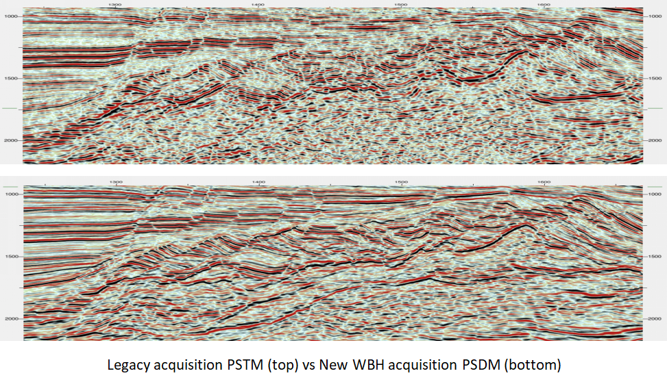
Seismic processing studies involve the application of various techniques and algorithms to raw seismic data to enhance its quality, extract useful information, and prepare it for interpretation. These studies are crucial in transforming raw seismic data into accurate and meaningful images of the subsurface, which are essential for geological and geophysical analysis.
Objectives of Seismic Processing Studies
1. Enhance Data Quality:
– Improve the signal-to-noise ratio, resolution, and overall clarity of seismic data to ensure accurate interpretation.
2. Correct for Acquisition Artifacts:
– Remove or mitigate artifacts introduced during data acquisition, such as multiples, noise, and geometric distortions.
3. Optimize Imaging of Subsurface Features:
– Generate accurate images of geological structures, stratigraphy, and reservoirs to support exploration and development decisions.
4. Prepare Data for Interpretation:
– Process the data to provide interpretable results, such as seismic volumes, attributes, and time-depth relationships.
Key Components of Seismic Processing Studies
1. Data Quality Assessment:
– Objective: Evaluate the initial quality of the raw seismic data to identify potential issues.
– Tasks:
– Visual Inspection: Review seismic traces for anomalies, noise, or gaps.
– Statistical Analysis: Analyze data characteristics such as amplitude distributions, noise levels, and signal-to-noise ratios.
2. Pre-Processing:
– Objective: Prepare raw seismic data for further processing by removing or reducing noise and artifacts.
– Tasks:
– Noise Attenuation: Apply techniques such as filtering, muting, or spectral whitening to reduce noise.
– Static Corrections: Apply near-surface corrections to account for variations in the travel time of seismic waves.
– Deconvolution: Enhance resolution by compressing the seismic wavelet and removing unwanted effects.
3. Velocity Analysis:
– Objective: Determine the velocity model used to convert seismic time data into depth data.
– Tasks:
– Velocity Picking: Identify and pick velocities for different layers and horizons.
– Velocity Modeling: Construct a velocity model that accurately represents subsurface velocity variations.
– Normal Moveout (NMO) Correction: Correct for the time delays caused by varying source-receiver offsets.
4. Migration:
– Objective: Correct for the distortions introduced by the Earth’s curvature and layering to produce an accurate image of subsurface structures.
– Tasks:
– Time Migration: Convert time-based seismic data into a time domain image.
– Depth Migration: Convert time-based seismic data into a depth domain image using the velocity model.
– Pre-Stack and Post-Stack Migration: Apply migration techniques before or after stacking data to improve image quality.
5. Stacking:
– Objective: Combine multiple seismic traces to enhance signal and improve data quality.
– Tasks:
– Common Midpoint (CMP) Stacking: Stack traces collected at the same midpoint to enhance signal-to-noise ratio.
– Velocity Stacking: Adjust stacking velocities to correct for deviations in seismic wave velocities.
6. Multiple Attenuation:
– Objective: Remove or mitigate the effects of multiple reflections that can obscure primary reflections.
– Tasks:
– Radon Transform: Apply a radon transform to identify and remove multiple reflections.
– Subtractive Methods: Use techniques to subtract multiple reflections from the seismic data.
7. Seismic Attributes Extraction:
– Objective: Derive additional information from the processed seismic data to enhance interpretation.
– Tasks:
– Amplitude Attributes: Extract attributes related to amplitude variations, such as amplitude maps or AVO (Amplitude Versus Offset) analysis.
– Coherence Attributes: Analyze attributes related to the coherence or discontinuity of seismic data, such as coherence or similarity maps.
– Frequency Attributes: Examine attributes related to frequency content, such as frequency decomposition or spectral analysis.
8. Time-to-Depth Conversion:
– Objective: Convert time-based seismic data into depth-based data for accurate subsurface imaging.
– Tasks:
– Depth Conversion: Apply the velocity model to convert time data into depth.
– Depth Migration: Refine depth conversion by applying migration techniques in the depth domain.
9. Quality Control (QC) and Validation:
– Objective: Ensure that the processing results are accurate and meet the desired quality standards.
– Tasks:
– Consistency Checks: Validate that processing results are consistent with geological expectations and well data.
– Data Review: Perform qualitative and quantitative reviews of processed data to identify and address any issues.
Recommendations for Successful Seismic Processing Studies
1. Define Clear Objectives:
– Establish clear processing objectives aligned with the geological and exploration goals to guide processing decisions.
2. Use Advanced Processing Techniques:
– Incorporate advanced techniques, such as iterative processing, machine learning algorithms, or enhanced migration methods, to improve data quality and resolution.
3. Integrate Well Data:
– Use well data, such as velocity logs or seismic-while-drilling data, to refine processing and improve the accuracy of seismic interpretations.
4. Regular Quality Checks:
– Implement regular quality control checks throughout the processing workflow to ensure that data quality is maintained and issues are addressed promptly.
5. Collaborate with Geoscientists:
– Engage geoscientists and interpreters throughout the processing stages to ensure that the processed data meets the needs of interpretation and decision-making.
6. Optimize Processing Parameters:
– Continuously refine processing parameters based on iterative testing and feedback to achieve the best results.
7. Document Processing Steps:
– Keep detailed records of processing steps, parameters, and decisions to facilitate reproducibility and future reference.
8. Consider Future Data Needs:
– Design processing workflows with future data integration and reprocessing in mind to ensure long-term value and usability of the seismic data.
Conclusion
Seismic processing studies are integral to transforming raw seismic data into actionable insights about the subsurface. By carefully applying and optimizing various processing techniques, geophysicists can enhance data quality, correct for acquisition artifacts, and produce accurate images of geological structures. Effective processing lays the groundwork for meaningful interpretation and informed decision-making in exploration and development projects.

Seismic acquisition budgeting is a critical aspect of planning and managing seismic surveys. It involves estimating and allocating the financial resources required for all stages of a seismic survey, from initial planning through data acquisition and initial processing. Proper budgeting ensures that the survey is conducted efficiently and within financial constraints while meeting the technical and operational objectives.
Key Components of Seismic Acquisition Budgeting
1. Survey Planning Costs
– Pre-Survey Studies: Costs associated with geological and geophysical studies, site surveys, and environmental assessments.
– Permitting and Approvals: Expenses related to obtaining necessary permits, licenses, and regulatory approvals.
2. Personnel Costs
– Field Crew: Salaries and expenses for geophysicists, surveyors, and field technicians.
– Management and Support Staff: Costs for project managers, administrative staff, and other support roles.
3. Equipment Costs
– Seismic Sources: Expenses for acquiring or renting seismic sources such as vibrators, air guns, or dynamite.
– Receivers: Costs for geophones, hydrophones, or other data acquisition sensors.
– Recording Equipment: Costs for data acquisition systems and related hardware.
– Transportation and Logistics: Expenses for moving equipment to and from the survey site, including transportation and handling.
4. Operational Costs
– Mobilization and Demobilization: Costs associated with moving personnel and equipment to and from the survey location.
– Daily Operations: Ongoing costs for fuel, maintenance, and operation of equipment.
– Camp and Accommodation: Expenses for setting up and maintaining field camps or accommodations for personnel.
5. Data Acquisition Costs
– Survey Design Implementation: Costs associated with implementing the survey design, including layout and setup.
– Field Data Collection: Expenses related to actual data acquisition, including any additional survey lines or supplementary data collection.
6. Health, Safety, and Environmental (HSE) Costs
– Safety Equipment and Training: Costs for personal protective equipment (PPE), safety training, and emergency response plans.
– Environmental Management: Expenses for managing environmental impact, including mitigation measures and compliance with regulations.
7. Data Processing and Quality Control
– Initial Data Processing: Costs for preliminary processing of seismic data to ensure quality and completeness.
– Quality Assurance: Expenses for ongoing quality control measures during data acquisition and processing.
8. Contingency Funds
– Unexpected Costs: A reserve budget to cover unforeseen expenses or issues, such as equipment failure or weather delays.
9. Miscellaneous Costs
– Communication and Reporting: Costs for communication with stakeholders, reporting, and documentation.
– Legal and Administrative Fees: Expenses related to legal consultations, contracts, and other administrative requirements.
Steps in Seismic Acquisition Budgeting
1. Define Project Scope and Objectives
– Clearly outline the scope of the seismic survey, including the objectives, area of interest, survey type, and expected deliverables. This will help determine the resources required.
2. Prepare Detailed Cost Estimates
– Break down costs into categories such as personnel, equipment, operations, and HSE. Gather quotes and estimates from vendors and service providers to ensure accuracy.
3. Develop a Budget Plan
– Create a comprehensive budget plan that includes all estimated costs, contingency funds, and a timeline for expenditure. Ensure that the budget aligns with project objectives and financial constraints.
4. Review and Validate Budget
– Review the budget with key stakeholders, including project managers, geophysicists, and financial analysts, to validate estimates and ensure completeness.
5. Monitor and Control Costs
– Implement a monitoring system to track actual expenditures against the budget. Regularly review and adjust the budget as necessary to address any discrepancies or unforeseen costs.
6. Document and Report
– Maintain detailed records of all expenditures and budget adjustments. Prepare regular reports to keep stakeholders informed of budget status and any changes.
Recommendations for Effective Seismic Acquisition Budgeting
1. Accurate Cost Estimation
– Use detailed estimates and quotes from reputable sources to ensure accurate budgeting. Consider both direct and indirect costs.
2. Include Contingency Funds
– Allocate a reasonable percentage of the budget for contingencies to manage unexpected costs effectively.
3. Engage Experts
– Involve experienced geophysicists, project managers, and financial analysts in the budgeting process to ensure that all aspects of the survey are considered.
4. Regular Budget Reviews
– Conduct regular budget reviews to monitor progress and address any issues promptly. Adjust the budget as necessary based on actual costs and project changes.
5. Optimize Resource Allocation
– Optimize the use of resources to balance cost and efficiency. Consider options for equipment rental versus purchase and explore cost-saving measures.
6. Maintain Flexibility
– Be prepared to adjust the budget and project plans in response to unforeseen challenges or changes in project scope.
7. Document Everything
– Keep thorough records of all budget-related decisions, expenditures, and changes to ensure transparency and facilitate future audits.
8. Plan for Future Needs
– Consider the potential need for additional surveys or data processing in the future and budget accordingly to ensure continuity and long-term value.
Conclusion
Seismic acquisition budgeting is a vital part of planning and executing a successful seismic survey. By carefully estimating and managing costs, including personnel, equipment, operations, and HSE considerations, organizations can ensure that the survey is conducted within budget and meets its technical objectives. Effective budgeting also helps mitigate risks and manage unexpected challenges, contributing to the overall success of the seismic exploration project.

Seismic operations management encompasses the planning, execution, and oversight of seismic surveys to ensure they are conducted efficiently, safely, and effectively. It involves coordinating various aspects of the seismic acquisition process, from mobilization to data acquisition, and ensuring that all operations align with project objectives and regulatory requirements.
Key Components of Seismic Operations Management
1. Project Planning and Coordination
– Survey Design: Develop a detailed survey design that includes the survey area, source and receiver configuration, and acquisition parameters.
– Resource Allocation: Plan and allocate necessary resources, including personnel, equipment, and logistics.
– Timeline and Milestones: Establish a project timeline with key milestones and deadlines.
2. Permitting and Regulatory Compliance
– Permitting: Obtain all necessary permits and approvals from regulatory authorities.
– Regulatory Compliance: Ensure that all operations adhere to local, regional, and national regulations, including environmental and safety standards.
3. Mobilization and Demobilization
– Mobilization: Coordinate the transportation and setup of equipment and personnel at the survey site.
– Demobilization: Plan for the removal and transportation of equipment and personnel once the survey is complete.
4. Field Operations Management
– Daily Operations: Oversee daily field operations, including data acquisition, equipment maintenance, and personnel management.
– Quality Control: Implement quality control procedures to monitor data quality and address any issues promptly.
– Health, Safety, and Environmental (HSE) Management: Ensure compliance with HSE standards, including safety protocols and environmental protection measures.
5. Data Acquisition and Processing
– Data Collection: Manage the acquisition of seismic data, including the deployment of sources and receivers and the recording of data.
– Data Quality Assurance: Monitor data quality in real-time and perform necessary adjustments to optimize data collection.
– Initial Processing: Conduct preliminary data processing to assess data quality and make any required corrections.
6. Communication and Reporting
– Internal Communication: Maintain clear communication among team members and departments to ensure smooth operations.
– External Communication: Liaise with stakeholders, including clients, regulatory agencies, and local communities.
– Reporting: Prepare and submit regular progress reports, including operational status, data quality, and any issues encountered.
7. Risk Management
– Risk Assessment: Identify potential risks related to operations, safety, and environmental impact.
– Mitigation Strategies: Develop and implement risk mitigation strategies to minimize the impact of identified risks.
8. Cost Management
– Budget Monitoring: Track expenses against the budget and manage any deviations.
– Cost Optimization: Identify opportunities for cost savings without compromising quality or safety.
9. Post-Operation Review and Evaluation
– Performance Review: Evaluate the performance of the seismic survey, including the effectiveness of operations and adherence to objectives.
– Lessons Learned: Document lessons learned and best practices for future surveys.
Steps in Effective Seismic Operations Management
1. Define Project Objectives and Scope
– Clearly define the objectives of the seismic survey, including the geological targets, data requirements, and survey parameters.
2. Develop a Detailed Operations Plan
– Create a comprehensive operations plan that outlines the steps required to achieve project objectives, including mobilization, data acquisition, and demobilization.
3. Assemble a Skilled Team
– Assemble a team of experienced professionals, including geophysicists, engineers, technicians, and safety experts.
4. Ensure Equipment Readiness
– Verify that all equipment is in good working condition, calibrated, and ready for deployment.
5. Implement a Communication Plan
– Develop a communication plan that ensures effective coordination among team members and with external stakeholders.
6. Monitor Operations in Real-Time
– Use real-time monitoring systems to track the progress of operations and address any issues as they arise.
7. Conduct Regular Safety and Quality Checks
– Perform regular safety inspections and quality checks to ensure compliance with standards and protocols.
8. Manage Environmental and Community Relations
– Address environmental concerns and engage with local communities to minimize impact and build positive relationships.
9. Evaluate and Document Results
– After completing the survey, evaluate the results and document any challenges or successes to inform future operations.
Recommendations for Effective Seismic Operations Management
1. Thorough Planning
– Invest time in thorough planning to ensure all aspects of the survey are considered and addressed before operations begin.
2. Strong Leadership
– Provide strong leadership and clear direction to ensure that the team remains focused and motivated.
3. Robust Safety Protocols
– Implement and enforce robust safety protocols to protect personnel and equipment.
4. Effective Communication
– Maintain open and effective communication channels to ensure that all stakeholders are informed and involved.
5. Continuous Monitoring
– Continuously monitor operations to identify and resolve issues promptly and ensure that the survey stays on track.
6. Flexibility and Adaptability
– Be prepared to adapt to changing conditions or unexpected challenges, and adjust plans as needed to address new developments.
7. Cost Control
– Keep a close eye on costs and look for opportunities to optimize spending without compromising on quality or safety.
8. Post-Project Evaluation
– Conduct a thorough evaluation of the survey upon completion to identify areas for improvement and apply lessons learned to future projects.
Conclusion
Effective seismic operations management is essential for the successful execution of seismic surveys. By carefully planning and coordinating all aspects of the survey, managing resources and risks, and ensuring compliance with regulations, organizations can achieve their exploration and development goals efficiently and safely. Strong operations management not only enhances the quality of the seismic data but also contributes to overall project success and stakeholder satisfaction.

Vertical Seismic Profile (VSP) Processing involves analyzing seismic data collected from sensors placed within a wellbore to gain detailed information about subsurface structures. The VSP technique provides high-resolution data on geological formations and is particularly useful for calibration of surface seismic data, reservoir characterization, and well-to-seismic tie.
Key Components of VSP Processing
1. Data Acquisition
– Wellbore Setup: Seismic sources (e.g., vibrators or explosives) are positioned at the surface or within the wellbore, and receivers (geophones or hydrophones) are placed at various depths within the well.
– Source and Receiver Configurations: Record the arrival times of seismic waves as they travel from the source to the receivers at different depths.
2. Pre-Processing
– Noise Reduction: Apply filtering techniques to remove unwanted noise and enhance the quality of the recorded signals.
– Calibration: Ensure that the recorded data is calibrated with respect to time, depth, and amplitude.
3. Data Correction
– Time Corrections: Adjust for differences between surface and wellbore data, such as travel time corrections and depth adjustments.
– Velocity Analysis: Correct for variations in seismic wave velocities in the wellbore and surrounding formations.
4. Data Integration and Alignment
– Depth Conversion: Convert time-based data into depth-based data to align with other subsurface information.
– Surface Seismic Tie: Integrate VSP data with surface seismic data to improve the accuracy of subsurface imaging.
5. Data Processing Techniques
– Waveform Analysis: Analyze the recorded waveforms to identify reflections and refractions, providing insights into subsurface structures.
– Amplitude Analysis: Examine the amplitude variations of seismic waves to detect changes in rock properties and fluid content.
– Velocity Analysis: Perform analysis of seismic wave velocities to understand the subsurface velocity model.
6. Inversion and Modeling
– Seismic Inversion: Use inversion techniques to convert seismic data into a more detailed subsurface model, providing information about rock properties and fluid distribution.
– Modeling: Create detailed geological models based on the processed VSP data to enhance reservoir characterization.
7. Quality Control and Interpretation
– Quality Checks: Conduct quality control checks to ensure the accuracy and reliability of the processed data.
– Interpretation: Interpret the processed data to identify geological features, such as faults, fractures, and reservoir boundaries.
Steps in VSP Processing
1. Data Collection
– Prepare the Wellbore: Ensure the wellbore is ready for seismic data acquisition, with properly calibrated equipment.
– Record Data: Conduct the VSP survey by generating seismic waves and recording their travel times and amplitudes at different depths.
2. Initial Processing
– Pre-Processing: Apply filtering and noise reduction techniques to clean the data.
– Data Calibration: Adjust for time and depth discrepancies and calibrate the data for accurate interpretation.
3. Depth Conversion and Alignment
– Convert Time to Depth: Use velocity information to convert time-based data into depth-based data.
– Align with Surface Data: Integrate VSP data with surface seismic data for a comprehensive subsurface view.
4. Advanced Processing
– Analyze Waveforms: Perform detailed waveform analysis to detect and characterize subsurface features.
– Apply Inversion Techniques: Use inversion methods to refine subsurface models and obtain detailed information about rock properties.
5. Interpretation and Analysis
– Conduct Interpretation: Analyze the processed VSP data to identify key geological features and structures.
– Integrate with Other Data: Combine VSP data with other geological and geophysical information for a complete understanding of the subsurface.
6. Report and Documentation
– Prepare Reports: Document the processing steps, results, and interpretations in detailed reports.
– Share Findings: Communicate findings with stakeholders, including geologists, reservoir engineers, and decision-makers.
Recommendations for Effective VSP Processing
1. Accurate Calibration
– Ensure that all equipment is accurately calibrated to produce reliable data.
2. Comprehensive Pre-Processing
– Apply thorough pre-processing techniques to clean and enhance the quality of the data.
3. Integrated Approach
– Integrate VSP data with surface seismic data and other geological information for a more complete subsurface model.
4. Advanced Techniques
– Utilize advanced processing techniques, such as inversion and modeling, to extract detailed information from the VSP data.
5. Regular Quality Control
– Implement regular quality control measures to ensure the accuracy and reliability of the processed data.
6. Effective Communication
– Clearly document and communicate the results and interpretations to all relevant stakeholders.
Conclusion
Vertical Seismic Profile (VSP) processing is a crucial technique in subsurface exploration and reservoir characterization. By acquiring and processing high-resolution seismic data from within a wellbore, VSP provides valuable insights into geological structures and rock properties. Effective VSP processing involves careful data acquisition, pre-processing, depth conversion, advanced analysis, and integration with other subsurface information. Proper execution of these steps ensures accurate interpretation and enhances the understanding of subsurface conditions, supporting informed decision-making in exploration and development projects.
The mission of Syntillica is to provide the best quality consulting support to the Energy Industry.